|
IFL Mapping
The IFL Methodology was proposed by Greenpeace in 2001 as an approach for mapping and monitoring the extent of forest degradation. The essence of the approach is to establish the boundaries of large undeveloped forest areas, or Intact Forest Landscapes (IFL), and to provide timely monitoring of forest conversion and degradation within them. The IFLs are defined as large unbroken expanses of natural ecosystems in the zone of current forest landscapes extent without signs of significant human activity. For the global IFL analyses, the following criteria were
|
|
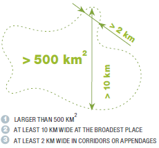
used: (1) minimum area of 50,000 hectares; (2) minimum IFL patch width of 10 km; and (3) minimum corridor/appendage width of 2 km. The criteria were chosen to insure that IFL patch core areas are large enough to provide refuge for wide-ranging animal species.
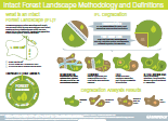
Intact Forest Landscape methodology at a glance
|
Medium resolution satellite data were used to map areas affected by alteration or conversion (clearing, logging, infrastructure development, etc.). Medium spatial resolution images from Landsat TM circa year 1990 and ETM+ circa year 2000 were used as the primary data source for year 2000 IFL mapping. The Landsat images were obtained from the GeoCover Landsat Orthorectified image collection (provided by GLCF and USGS). Both sets of 1990 and 2000 Landsat TM/ETM+ images were used simultaneously to improve the quality of interpretation. While the year 2000 images made it possible to detect the most recent disturbances, the older
|
images allowed us to detect older disturbances, whose traces have become less evident with time. This was especially important in tropical forests, where the evidence of human influence disappears much faster than in temperate and boreal forests. Existing road and settlement maps and high spatial resolution imagery available through Google Earth interface were used to aid interpretation.
The IFL mapping approach is based on ‘inverse logic’, i.e. on mapping the opposite of intactness: altered and fragmented forest areas. The image analysis was conducted through expert-based visual interpretation, using Geographic Information System (GIS) overlays of medium spatial resolution satellite images with additional thematic and topographic map layers. The purpose is to detect evidence of significant human-caused alteration and fragmentation. To assess fragmentation, all developed areas were excluded and all infrastructure and settlements were buffered by 1 km. Patches without evidence of development, if large enough, are classified as IFL. The IFL Mapping Team produced and provides regular updates of the global IFL map which shows the boundary between unaltered forest landscapes (where most components, including species and site diversity, dynamics and ecological functions remain intact) and altered or fragmented forests (where some level of timber extraction, species composition change, anthropogenic fragmentation and/or alteration of ecosystem dynamics has taken place). The IFL methodology represents a practical, rapid, and cost-effective approach for assessing forest intactness, alteration and degradation at the global and regional scales.
 |
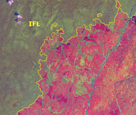 |
Democratic Republic of the Congo. Settlements, agriculture areas and buffered area along the road have been excluded. |
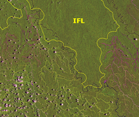
Democratic Republic of the Congo. Savanna grazing areas affected by annual human induced fires have been excluded. |
 |
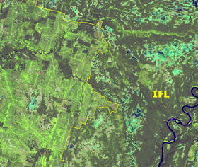 |
Papua - New Guinea. Logging concession area have been excluded. |
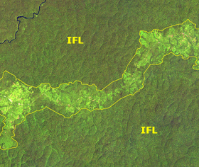
Northern European Russia. Clearcuts have been excluded. |
Examples of IFL boundaries (yellow line) mapped on Landsat ETM+ images
IFL Monitoring
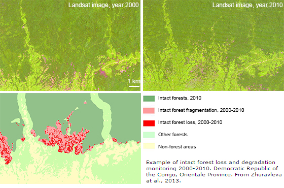
The IFL re-assessment and global map update can be used to measure and differentiate rates of forest alteration and degradation across a landscape. To perform the update we use the same criteria, source data, and methods as in the baseline year 2000 assessment. The work is conducted through expert-based visual interpretation of medium spatial resolution satellite imagery, and could proceed much more quickly than the initial IFL baseline mapping because only areas within already identified IFLs needed to be assessed (no gain in intactness is assumed to be possible). For the year 2013 update the cloud-free mosaic of Landsat data provided by University of Maryland were used as a source data. Combining IFL degradation maps with gross forest cover loss results (e.g. Hansen et al., 2013) may be used to differentiate causes of IFL degradation.
References:
P. Potapov, A. Yaroshenko, S. Turubanova, M. Dubinin, L. Laestadius, C. Thies, D. Aksenov, A. Egorov, Y. Yesipova, I. Glushkov, M. Karpachevskiy, A. Kostikova, A. Manisha, E. Tsybikova, and I. Zhuravleva. (2008) Mapping the world’s intact forest landscapes by remote sensing. Ecology and Society 13(2): 51
I. Zhuravleva, S. Turubanova, P. Potapov, M. Hansen, A. Tyukavina, S. Minnemeyer, N. Laporte, S. Goetz, F. Verbelen and C. Thies (2013) Satellite-based primary forest degradation assessment in the Democratic Republic of the Congo, 2000–2010. Environmental Research Letters 8: 024034
|
|
|